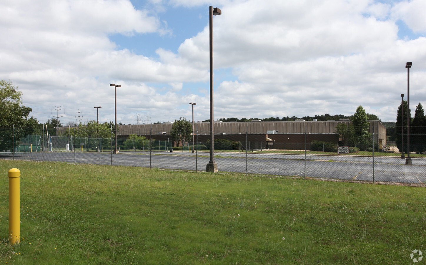
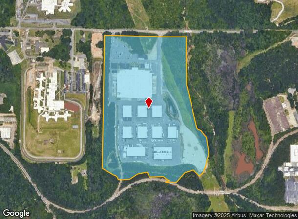
Property Record
1415 Constitution Rd Se, Atlanta, GA 30316

NEARBY LISTINGS FOR SALE OR LEASE
Property Detail
1415 Constitution Rd Se
15-079-01-018
DeKalb
Recreationalentertainmentgeneral
Georgia
AE
18
13089C0137J
52.30 AC
2023
Snapfinger
2023
Atlanta
023802
Atlanta-Sandy Springs-Roswell, GA
381,983 SF
DEMOGRAPHICS near 1415 Constitution Rd Se
1 Mile
3 Mile
5 Mile
2024 Total Population
1,849
54,213
206,627
2029 Population
1,899
55,205
211,557
Pop Growth 2024-2029
+ 2.70%
+ 1.83%
+ 2.39%
Average Age
38
38
37
2024 Total Households
522
19,728
83,458
HH Growth 2024-2029
+ 3.26%
+ 1.85%
+ 2.59%
Median Household Inc
$79,403
$57,899
$59,154
Avg Household Size
2.50
2.50
2.40
2024 Avg HH Vehicles
2.00
2.00
1.00
Median Home Value
$274,602
$257,498
$285,171
Median Year Built
1968
1976
1976
Nearby Places
- Restaurants
- Banks
- Shops
- Fitness
- Groceries
PUBLIC TRANSPORTATION
AIRPORT
Hartsfield - Jackson Atlanta International
DRIVE
WALK
Distance
Hartsfield - Jackson Atlanta International
19 min
9.3 mi
Freight Ports
Georgia Ports - Savannah
DRIVE
WALK
Distance
Georgia Ports - Savannah
273 min
242.2 mi
SALE & LEASE HISTORY
LISTING DATE
SALE/LEASE

Sep 24, 2016
For Lease
Nearby Properties
Address
Land Use
TOTAL SIZE
Lot Size
Zoning
Address
Land Use
TOTAL SIZE
Lot Size
Zoning
54 AC
I2
Address
Land Use
TOTAL SIZE
Lot Size
Zoning
81,129 SF
4.29 AC
C1
Address
Land Use
TOTAL SIZE
Lot Size
Zoning
375,336 SF
22.76 AC
M
Address
Land Use
TOTAL SIZE
Lot Size
Zoning
7.65 AC
R5
Address
Land Use
TOTAL SIZE
Lot Size
Zoning
118,310 SF
11.30 AC
RM85
Address
Land Use
TOTAL SIZE
Lot Size
Zoning
44,365 SF
18 AC
M
Address
Land Use
TOTAL SIZE
Lot Size
Zoning
210,538 SF
101.30 AC
X
Address
Land Use
TOTAL SIZE
Lot Size
Zoning
295,632 SF
18.10 AC
RM75
Address
Land Use
TOTAL SIZE
Lot Size
Zoning
91,446 SF
13.20 AC
RM85
Address
Land Use
TOTAL SIZE
Lot Size
Zoning
207,757 SF
19.20 AC
RM85
Address
Land Use
TOTAL SIZE
Lot Size
Zoning
197,671 SF
21.34 AC
X
Address
Land Use
TOTAL SIZE
Lot Size
Zoning
157,335 SF
68.70 AC
M
Address
Land Use
TOTAL SIZE
Lot Size
Zoning
278,121 SF
20.90 AC
RM85
Address
Land Use
TOTAL SIZE
Lot Size
Zoning
219,652 SF
27 AC
C1
Address
Land Use
TOTAL SIZE
Lot Size
Zoning
129,064 SF
13.29 AC
RM75
Address
Land Use
TOTAL SIZE
Lot Size
Zoning
73,184 SF
6.80 AC
RM85
Address
Land Use
TOTAL SIZE
Lot Size
Zoning
146,133 SF
16.60 AC
RM75
Address
Land Use
TOTAL SIZE
Lot Size
Zoning
102,447 SF
6.90 AC
RM75
Address
Land Use
TOTAL SIZE
Lot Size
Zoning
44,115 SF
9.84 AC
C1
Address
Land Use
TOTAL SIZE
Lot Size
Zoning
59,807 SF
42.40 AC
X
Address
Land Use
TOTAL SIZE
Lot Size
Zoning
73,195 SF
6.50 AC
RM75
Address
Land Use
TOTAL SIZE
Lot Size
Zoning
178,495 SF
11.90 AC
RM100
Address
Land Use
TOTAL SIZE
Lot Size
Zoning
13,108 SF
27.48 AC
M
Address
Land Use
TOTAL SIZE
Lot Size
Zoning
50 AC
R4
Address
Land Use
TOTAL SIZE
Lot Size
Zoning
271,487 SF
29.12 AC
RG2
Address
Land Use
TOTAL SIZE
Lot Size
Zoning
381,168 SF
19.70 AC
M
Address
Land Use
TOTAL SIZE
Lot Size
Zoning
157,248 SF
9.94 AC
RG2
Address
Land Use
TOTAL SIZE
Lot Size
Zoning
34.90 AC
R100
Address
Land Use
TOTAL SIZE
Lot Size
Zoning
39,950 SF
5.20 AC
RM-85
The World's #1 Commercial Real Estate Marketplace
Connect with us
© 2025 CoStar Group
The information above has been obtained from sources believed reliable. While we do not doubt its accuracy we have not verified it and make no guarantee, warranty or representation about it. It is your responsibility to independently confirm its accuracy and completeness. Any projections, opinions, assumptions, or estimates used are for example only and do not represent the current or future performance of the property. The value of this transaction to you depends on tax and other factors which should be evaluated by your tax, financial, and legal advisors. You and your advisors should conduct a careful, independent investigation of the property to determine to your satisfaction the suitability of the property for your needs.